
- Posts 164
- WRZ$
2.40
OziExplorer Desktop v3.95.5 and Android Extras
Requirements: Windows computer
Overview: This is the full desktop version of OziExplorer. It is useful for DEVICE users as you can calibrate your own maps from scanned or digital map images (JPG or PNG). This release also includes a detailed description of how to create your own map for Android devices.
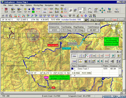
Other extras are included in the RAR too. OziExplorer for Desktop and OziExplorerCE for Android devcie allow you to scan, calibrate and create maps and then change them to a compressed format for use on your Pocket PC. Use the moving-map software to navigate off-road, ideal for flying, walking, driving and sailing.
The PPC's OziExplorer display is fully changable - you can create display pages of your own design if
you wish. Use your GPS to explore the outside world, ideal for flying, walking, driving and sailing.
Using the Desktop version of Ozi-Explorer, create digital maps that you have scanne, or purchase
commercial maps in various formats. By using these maps OziExplorer allows you to plan your trip by
creating waypoints, routes and tracks on screen and upload these to your GPS.
Plot your GPS position on Laptop or PocketPC while you follow your pre-defined track. Watch your
progress on a moving-map display. Highly flexible software for almost any GPS use.
* Use maps or charts which you can scan and calibrate yourself.
* Use maps in various formats - BSB, USGS DRG, ECW, SID, TIF, PNG, + more.
* Direct support for most Garmin, Magellan, Lowrance/Eagle, Brunton/Silva and MLR GPS receivers.
* Create Waypoints, Routes and Tracks on the map and upload these to your GPS (for supported GPS receivers).
* Download Waypoints, Routes and Tracks from your GPS and display them on a map.
* Specify permanent Map features on a map and attach a picture (or any file) to each feature.
* Place symbols and comments on the Map.
* Over 100 map Datums supported.
* Support for many Map projections and Grid systems.
* Print Maps and Waypoint Lists.
* Show your GPS position in real time on the map (moving map).
* In moving map mode you will navigate along your route giving instructions when each waypoint is reached.
* Various parameters such as Speed, Course, Next Waypoint, Distance, CTS, XTE, ETE and ETA are displayed.
* In moving map operation automatically changes to the next map.
* Android version screen designer program: re-design the app interface display to your own requirements.
More Info:
Download Instructions:
http://www.MegaShare.com/4182664
Requirements: Windows computer
Overview: This is the full desktop version of OziExplorer. It is useful for DEVICE users as you can calibrate your own maps from scanned or digital map images (JPG or PNG). This release also includes a detailed description of how to create your own map for Android devices.
Other extras are included in the RAR too. OziExplorer for Desktop and OziExplorerCE for Android devcie allow you to scan, calibrate and create maps and then change them to a compressed format for use on your Pocket PC. Use the moving-map software to navigate off-road, ideal for flying, walking, driving and sailing.
The PPC's OziExplorer display is fully changable - you can create display pages of your own design if
you wish. Use your GPS to explore the outside world, ideal for flying, walking, driving and sailing.
Using the Desktop version of Ozi-Explorer, create digital maps that you have scanne, or purchase
commercial maps in various formats. By using these maps OziExplorer allows you to plan your trip by
creating waypoints, routes and tracks on screen and upload these to your GPS.
Plot your GPS position on Laptop or PocketPC while you follow your pre-defined track. Watch your
progress on a moving-map display. Highly flexible software for almost any GPS use.
* Use maps or charts which you can scan and calibrate yourself.
* Use maps in various formats - BSB, USGS DRG, ECW, SID, TIF, PNG, + more.
* Direct support for most Garmin, Magellan, Lowrance/Eagle, Brunton/Silva and MLR GPS receivers.
* Create Waypoints, Routes and Tracks on the map and upload these to your GPS (for supported GPS receivers).
* Download Waypoints, Routes and Tracks from your GPS and display them on a map.
* Specify permanent Map features on a map and attach a picture (or any file) to each feature.
* Place symbols and comments on the Map.
* Over 100 map Datums supported.
* Support for many Map projections and Grid systems.
* Print Maps and Waypoint Lists.
* Show your GPS position in real time on the map (moving map).
* In moving map mode you will navigate along your route giving instructions when each waypoint is reached.
* Various parameters such as Speed, Course, Next Waypoint, Distance, CTS, XTE, ETE and ETA are displayed.
* In moving map operation automatically changes to the next map.
* Android version screen designer program: re-design the app interface display to your own requirements.
More Info:
Code: Select all
www.oziexplorer.comDownload Instructions:
http://www.MegaShare.com/4182664

VIP
Emeritus Moderator
Emeritus Moderator
- Posts 4324
- Location Austria
- WRZ$
33998.31
- Device Samsung Galaxy S4 (GT-i9505), Cyanogenmod 10.2.1
- OS Android 8
Please edit this release according to the "How to Post a Release" Sticky. Your release will not be rewarded or categorized until this is done. Once you have edited the release please click on the  beneath the post, select "Edited Release," and submit.
greetings
greetings

I retired from moderating Android. Thanks to raindrops, Mr FuFu, XVI, jimking & verdasco. We'll see us

Administrator
- Posts 34120
- Location Italy-Greece
- WRZ$
146708.56
- Device SGS7 Edge
Edited by me. Please next time edit it yourself.
Before make a new topic please:
- Read the Site Rules and How to Post a Release
- Use Search Bar for avoid double posts.
- Support developers!
- For PC and Android widgets - Animated Wallpapers check my Deviantart


- Read the Site Rules and How to Post a Release
- Use Search Bar for avoid double posts.
- Support developers!
- For PC and Android widgets - Animated Wallpapers check my Deviantart
Joehule wrote:Update for android (v1.34)?
Thanks
Seriously the topic is nearly 10yrs old and ya bumped it the user probably dosent even use here anymore